The French family of renowned cartographers, the Delisles,
publish the third of their groundbreaking maps, "Care de la
Louisiane et du Cours du Mississippi,' on which they showed
remarkably accurate information drawn from LaSalle's explorations,
much of Spanish country as far west as the upper Rio Grande, and
the Missouri reaching as far north as the Mandan Villages on the
upper Missouri, which were located more by the mist of supposition
based on information gathered on the lower Missouri.
Click here for more on this legendary
cartographer
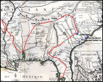 The Delisle map
derives much of its importance from the delineation of French and
Spanish claims in the valley of the Mississippi, the Spanish
possessions in Mexico, an Louisiana, at a time when Spain and
France were locked in a fierce argument over what belonged to
whom. Even though Delisle was French, his map accepts the
Spanish claim of discovery by DeSoto, in 1539, of the lands that
are now known as Florida, Georgia, the Carolinas, Alabama,
Mississippi, Arkansas, Louisiana, and Texas.
The Delisle map
derives much of its importance from the delineation of French and
Spanish claims in the valley of the Mississippi, the Spanish
possessions in Mexico, an Louisiana, at a time when Spain and
France were locked in a fierce argument over what belonged to
whom. Even though Delisle was French, his map accepts the
Spanish claim of discovery by DeSoto, in 1539, of the lands that
are now known as Florida, Georgia, the Carolinas, Alabama,
Mississippi, Arkansas, Louisiana, and Texas.
Delisle
improved greatly on earlier maps, incorporating the material of
earlier French cartographers with information gathered by Spanish
explorers.
The French
claim to segments of these lands was made by LaSalle a hundred and
forty-five years after DeSoto's expedition. After LaSalle was
murdered by one of his own men, his brother led the survivors of
the expedition overland to the mouth of the Arkansas River, then
north on the Mississippi to new France.
Thus, a see-saw
battle over two thirds of the American continent began. For
the next century, rival colonial powers would vie for ownership of
these rich but unknown lands. In 1712, the French crown
assumed ownership of all the land south of the Illinois River,
between the English on the east and the Spanish to the west, for
the purpose of opening commercial enterprises and building trade
with Spanish forts in Mexico. What is most notable about Delisle's
map is the depiction of the Missouri, the 'river of the West', its
many tributaries, and the location of many Indian tribes along its
meandering course - including the Mandan Villages in the far
north.
Naturally,
Delisle stretched his country's claims to their geographical
limits. For the most part, he got away with it. The
boundaries he inscribed on this famous map would be the boundaries
cited in the treaty between France and the United States, a century
later, when the territory of Louisiana was transferred to the
United States.
Related People
Related Events
Related Flashpoints
Related Places